Good morning,
I am a second-year Master's student in Environmental and Land Engineering at the Polytechnic University of Turin. For my thesis, I am processing thermal images captured with a DJI drone and using UAV4GEO’s Thermal Tool to convert them from R-JPG to TIFF format.
I am writing on behalf of myself and my supervisors to seek clarification regarding some issues encountered during the thermal image processing—specifically concerning the environmental parameters entered into the tool. When setting these parameters, we noticed that the data acquisition distance cannot exceed 25 meters (a limitation also observed when using the DJI Thermal SDK, which shares the same conversion model); however, the drone used for our project flew at much higher altitudes, often exceeding 200 meters. Since the Thermal SDK also specifies a 25-meter distance limit—instructing users to input this value even if the actual acquisition distance exceeds 25 meters—we were wondering if there is a way to enter a value higher than this imposed limit (notably, the error screen appearing in the tool when entering parameters like emissivity = 0.1 or reflected temperature > 100°C indicates a distance range of 1 to 300 meters). Alternatively, if this is not possible, we would like to know what impact setting the value to 25 meters has on the quality of the resulting conversion.
Thank you very much for your assistance.
Alessio Calì
UAV4GEO Thermal tool question
7 Replies
Hi Alessio! What sensor and SDK version are you using? I might be able to share my experience as I have been through this myself recently
EDIT: apologies I did not check the SDK version in ThermalTools. I will continue with my reply in a bit
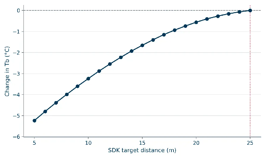
For my thesis, we flew with H20T at 40 meters AGL. We were curious about the exact same thing. We were capturing a peatland patch and fortunately there were some water ponds, so I cropped one of our images and extracted a homogeneous water patch of 50x50 pixels, ensured the emissivity is set to 1 and the parameters humidity and reflection set to default, and only changed the distance during the conversion to tiff. Here is how the temperature of the patch changed. The response is nonlinear.
It seems that the distance parameter can indeed be a problem for some applications requiring high measurement accuracy. I tested this out on version 1.18 of the SDK (I used an old one 1.15 in my thesis) and it seems that the 25 m distance cap has not been resolved yet. I remember looking for papers on this, and I think at least this one acknowledges the cap.
Note that the response is from the 40 m AGL flight and it might be different for your 200 m flight, I'd be curious to see it!
For such high flights, based on the discussions with other folks in academia who were doing a similar research, it seems that it would be better to stay away from the proprietary DJI thermal cameras for high accuracy demanding applications... If you care more about the relative temperature patters I suppose it is a lesser deal.
Let me know if I can be of any more help!
Daniela
Thanks a lot for te answer. I tried converting the thermal images we acquired with UAV4GEO setting the distance at 25 m but when i tried to open them on QGIS to visualize the result i noticed that the converted images had a wrong coordinate metadata (the images had no projection set and when i specified the reference system they were all overlapped. I tried opening the metadata of the converted images and the coordinates are correct but in QGIS they are not applied) and also the number of pixel in the converted image has been halved (the original image was 1280x1024 while the converted one was 640x512). Did you or someone else have the same problem?
I think you're expecting the tool to georeference/reproject the thermal images as GeoTIFF, but that's not what the tool does, ThermalTools extracts the celsius values (which are 640x512) to a standard 32bit TIFF and copies the EXIF meta from the original image. If you want to see the results on a map, first process the images with WebODM.
Thanks for the clarification, insetad for the cap of 25 m tò the acquisition distance Is there a way to raise the distance value? And of not how does the distance impact on the result of the conversion with a distance of acquisition that is much higher than the limit (we flew at around 200-250 metres)?
The distance 25 m is unfortunately the capped maximum. I am not familiar with the SDK binaries and maybe it would be possible to tinker with it, but I am not sure if it would be a right direction. I think all we can do with DJI thermal sensors is just to simulate what the distance parameter does to the measurements. Once upon a time I was reading through some forums to see if someone had managed to reverse-engineer the equations for H20T's radiometric calibration but I didn't find anything...
Honestly I am not sure why it is capped to 25 m. Could it be that they had some specific industrial applications in mind?
I am however going to run some experiments; I have some more datasets of the same study area taken at 50 m AGL and 100 m AGL. I will take a look at what the distance parameter does to the water patches taken from these altitudes and share it here. It should change things a bit as the reflected radiance has to travel a longer path through the atmosphere to reach the sensor
FWIW I wonder if the thermal cap of 25m is a matter of calibration and manufacturing production. These thermal sensors are affected by ambient environment and sensor sizes. Not unlike regular rgb camera sensor size dictates the megapixel value and how much light is possible to capture. Both sensors can take photos from any distance but pixel value and resolution is limited by sensor sizes.
With thermal the resolution is already much less than an rgb camera in the same machine and determining accurate radiance is impacted. Then processing the captured results to models and maps is a matter of sfm/ODM doing the best it can on lower resolution pixels.
Also I was once told for these cameras to effectively detect thermal difference the subjects need to have a certain temperature difference for the sensor to detect thermal difference. If a subject (person) is 98deg f and the ambient environment (ground) is also 98deg f then the sensor detects all of the radiance as the same value. That could also be an impacted factor with 25m cap and results.
Need more help?
This discussion happened in the WebODM community Discord. Join and ask your own question.
Join View Original ThreadThis page mirrors a public discussion from the WebODM Discord. How to request a removal.